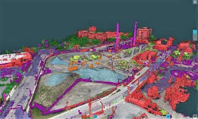
Gradework Streamlines the Construction from Initial Bid to Final Delivery Working from PDF, CAD or manual entry, Gradework allows contractors to analyze data for more accurate bids, efficient site management, and successful project completions.
Vendor
Hexagon
Company Website


Overview
AGTEK's Gradework is a comprehensive construction takeoff and modeling software designed to streamline the construction process, from initial bidding to project delivery. It enables contractors to work with data from PDFs, CAD files, or manual entries, facilitating accurate analysis for precise bids, efficient site management, and successful project completions. Gradework's intuitive interface and advanced features enhance productivity and decision-making throughout the construction lifecycle.
Features and Capabilities
Takeoff & Control:
- Provides immersive 3D visualizations for project phasing.
- Enables extraction of volumes, strata details, and sectional areas with high accuracy.
- Facilitates value engineering to assess risks and optimize plans pre-construction.
- Integrates drone technology to verify existing site conditions.
Grade Control Models:
- Generates machine control models compatible with GPS systems from major manufacturers.
- Allows precise control of dozers, excavators, graders, and other machinery.
- Supports single-brand and mixed fleets, simplifying data preparation.
- Exports linework in multiple formats, enhancing site efficiency.
Data Integration and Analysis:
- Utilizes data from drones, CAD files, and point clouds for decision-making.
- Calculates stockpile volumes and over-excavation quantities.
- Monitors earthwork progress throughout the construction process.
Utility Modeling and Analysis:
- Models storm, sewer, water, and other utilities with trench and pipe details.
- Detects utility clashes and provides trench analysis to optimize installations.
Enhanced User Interface:
- Features simplified label editing and quick assignment options.
- Includes versatile borehole input options for strata.
- Offers selective display of surface lines in profile views.
Guided Workflows:
- Provides step-by-step instructions for volume computation and staged excavations.
- Assists with accurate analysis of drone and GPS survey data.
Production Tracking:
- Tracks production using machine data and drones.
- Monitors fleet performance with detailed metrics like cycle times and material volumes.
- Optimizes resource usage to ensure timely project completion.
Reporting and Collaboration:
- Generates progress reports and enables team collaboration.
- Provides mobile apps for real-time data access and updates from the field.
- Enhances geospatial visualization with integrated mapping tools.